
Some year ago Wokingham Borough Council decided to throw out some large`(72x101cm) linen backed Ordnance Survey maps of (parts) of Wokingham from the 1870’s to 1890’s. An individual “saved” eight of these and they have been in a loft for a number of years before he transferred ownership to Wokingham Town Council in November 2019. There are two types of maps, “normal” maps and “The Borough Of Wokingham Sewer” maps. Neither are complete sets of Wokingham.
Three of the maps have been photographed by way of examples.
There follows a description of each of the maps:-
…………………………………………………………………………………………………………
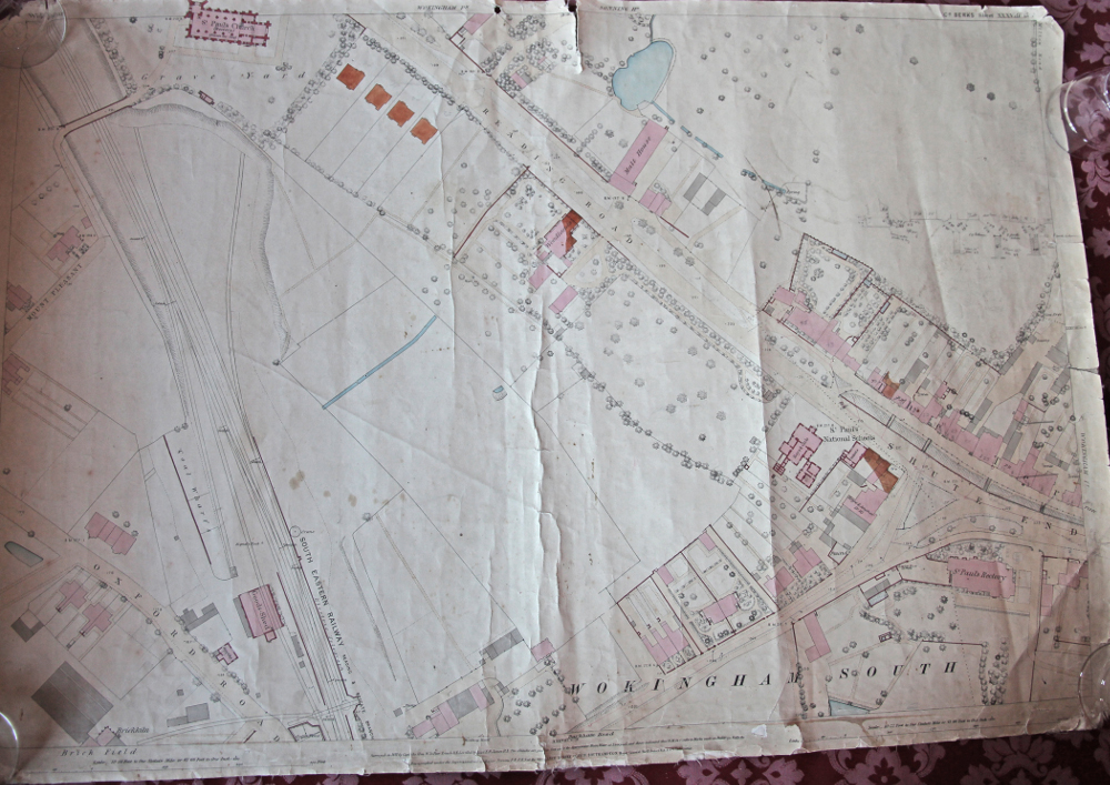
Ref: Co. BERKS Sheet XXXVIII.15
Scale: 10.56 feet to one statute mile
Surveyed: In 1871 by Capt. The honourable W. Lepoer Trench R.E.
Levelled: By Capt. E.R. James R.E.
Altitudes: The altitudes are given in feet above the approximate Mean Water at Liverpool, and are indicated in the format (B.M. 54.7) which refers to Masks made in buildings, walls etc.
Acknowledgments: Zincographed under Superintendence of Major Parsons R.E.F.R.S. at the Ordnance Survey Office, Southampton. Major General Sir. H James R.E.F.R.S, &c. Director.
Areas Covered Or Part Covered: St.Paul’s Church, Reading Road, Shute End, St. Paul’s Rectory, South East Railway, Mount Pleasant, Oxford Road.
…………………………………………………………………………………………………………
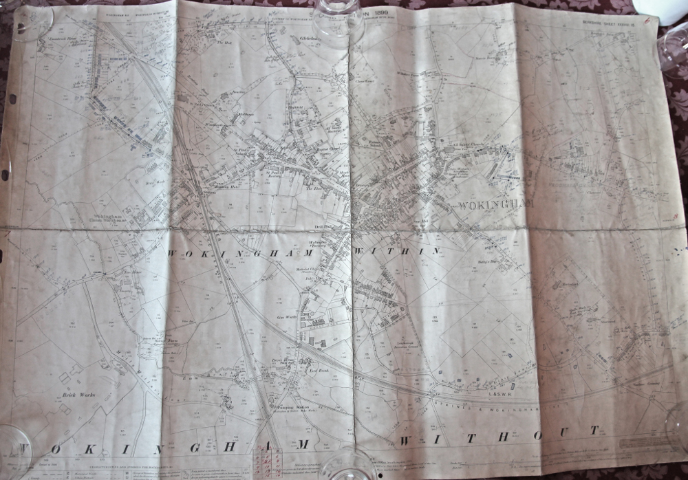
Ref: BERKSHIRE Sheet XXXVIII.15 SECOND EDITION 1899
A copy of this is held in Wokingham Ref. Library but that version is in poor condition.
Scale: 1/2500 being 25.344 inches to a statute mile
Surveyed: In 1871 by Capt. the honourable W. Lepoer Trench R.E. and Revised in 1898.
Levelled: By Capt. E.R. James R.E.
Altitudes: The altitudes are given in feet above the assumed level of the sea at Liverpool which is 0.650 of a foot below the general Mean Level of the sea.
Acknowledgments: Heliozincograhed and Published at the Ordnance Survey Office, Southampton, 1899.
Edward Stanford, 12,13&14 Long Acre W.C. Geographer to the King. London Agent by appointment for the sale of the Ordnance Survey Maps &c. Agent for Admiralty Charts. The Indian Government Maps &c.
Areas Covered Or Part Covered: Oxford Road, Shute End, Market Place, Peach Street. London Road, Easthampstead Road, Denmark Street, Langborough Road, Gypsy Lane, Finchampstead Road, Molly Millars Lane, Barkham Road, Brick Works, Gleblands, All Saints Church, Station, Brewery, Baptist Church, Wokingham Union Workhouse
……………………………………………………………………………………………………………
Ref: BERKSHIRE WOKINGHAM Sheet XXXVIII.15.12
Scale: 10.56 feet to one statute mile
Surveyed: In 1871 Re-Zincgraphed and Published in 1892 at the Ordnance Survey Office, Southampton.
Altitudes: The altitudes are given in feet above the assumed level of the sea at Liverpool which is 0.650 of a foot below the general Mean Level of the sea.
Price: Coloured 4/- Uncoloured 2/6
Areas Covered Or Part Covered: Barkham Road, Wellington Road, Havelock Road, Staines, Wokingham & Reading Railway
……………………………………………………………………………………………………………
Ref: No I BOROUGH OF WOKINGHAM PLAN OF SEWERS BERKSHIRE Sheet XXXVIII.15 NW
Scale: Specially enlarged from 1/2500 scale plans for the land valuation department, Inland Revenue
Acknowledgments: Printed at the Ordnance Survey Office, Southampton in 1991
Edward Stanford, 12,13&14 Long Acre W.C. Cartographer to the King. London Agent for the Admiralty Charts, the Indian Government Map & c.
Areas Covered Or Part Covered: Reading Road, Holt Lane, The Terrace, Broad Street, Station Road, Station, Oxford Road, Havelock Place, Havelock Road, All Saints Rectory, Emmbrook House.
……………………………………………………………………………………………………………
Ref: No III BOROUGH OF WOKINGHAM PLAN OF SEWERS BERKSHIRE Sheet XXXVIII.15 SW
Scale: Specially enlarged from 1/2500 scale plans for the land valuation department, Inland Revenue
Acknowledgments: Printed at the Ordnance Survey Office, Southampton in 1991
Edward Stanford, 12,13&14 Long Acre W.C. Cartographer to the King. London Agent for the Admiralty Charts, the Indian Government Map & c.
Areas Covered Or Part Covered: Barkham Road, Tannery, Molly Millars, Sewage Farm, Pumping Station, Gas Works, Finchampstead Road, Wellington Road, Carey Road, Norton Road, Denmark Street, Wellington Brewery, Brick Works, Tannery, Sewage Farm.
……………………………………………………………………………………………………………
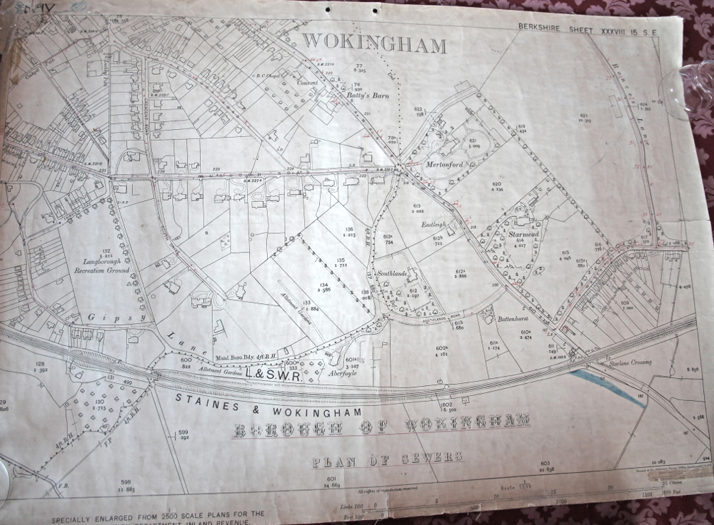
Ref: No IV BOROUGH OF WOKINGHAM PLAN OF SEWERS BERKSHIRE Sheet XXXVIII.15 SE
Scale: Specially enlarged from 1/2500 scale plans for the land valuation department, Inland Revenue
Acknowledgments: Printed at the Ordnance Survey Office, Southampton in 1991
Edward Stanford, 12,13&14 Long Acre W.C. Cartographer to the King. London Agent for the Admiralty Charts, the Indian Government Map & c.
Areas Covered Or Part Covered: Easthampstead Road, Murdoch Road, Gipsey Lane, Southlands Road, Fairview Road, Staines & Wokingham Railway, Waterloo Road, Rances Lane, Crescent Road, Cockpit Path, South Drive.
……………………………………………………………………………………………………………
Ref: BERKSHIRE Sheet XXXVIII.15.14
Scale: 10.56 feet to one statuette mile
Surveyed: In 1871 by Capt. the honourable W. Lepoer Trench R.E. and Revised in 1898.
Levelled: By Capt. E.R. James R.E.
Altitudes: The altitudes are given in feet above the assumed level of the sea at Liverpool which is 0.650 of a foot below the general Mean Level of the sea.
Acknowledgments: Zincographed under Superintendence of Major Parsons R.E.F.R.S. at the Ordinance Survey Office, Southampton. Major General Sir. H James R.E.F.R.S, &c. Director.
Edward Stanford, 12,13&14 Long Acre W.C. Geographer to the King. London Agent by appointment for the sale of the Ordnance Survey Maps &c.
Areas Covered Or Part Covered: Star Lane, Batty’s Barn
……………………………………………………………………………………………………………
Ref: Co. BERKSHIRE Sheet XXXVIII.15.8
A copy of this is held in Wokingham Ref. Library but that version is in poor condition
Scale: 10.56 feet to one statute mile
Surveyed: Zincographed under Superintendence of Major Parsons R.E.F.R.S. at the Ordnance Survey Office, Southampton. Major General Sir. H James R.E.F.R.S, &c. Director.
Altitudes: The altitudes are given in feet above the assumed level of the sea at Liverpool which is 0.650 of a foot below the general Mean Level of the sea.
Price: 4/-
Areas Covered Or Part Covered: Milton Road, Baptist Church, Shute End, Broad Street, Montague House, Rose Street.
Wokingham Town Museum Unique Identifier: WTH0597